
The International Tribunal for the Law of the Sea (ITLOS) has ruled that Maldives should get a larger share of the disputed waters between Maldives and Mauritius.
In July 2010, Maldives submitted its claims to the United Nations for an extended continental shelf and new coordinates that claimed the full 200 nautical mile EEZ measured from Addu Atoll, the southern-most atoll in the country. This ignored the 1992 understanding with the United Kingdom and was also inconsistent with Maldives’ previous willingness to negotiate overlapping EEZs with Sri Lanka and India, its northern neighbours.
Maldives argued that Chagos was a unique case because it does not possess a population dependent on fishing, or indeed any permanent population at all – an argument apparently not supported by the UN Convention on the Law of the Sea (UNCLOS), which allows EEZs to be claimed for any habitable island whether or not it is inhabited.
Mauritius then entered the fray, protesting against both the United Kingdom and Maldives. Maldives did not officially take any position over Chagos sovereignty and had previously declined to negotiate with Mauritius over maritime boundaries. However, in 2011, President of Maldives Mohamed Nasheed, during a visit to Mauritius, issued a joint communiqué stating that the two countries would make a “collective stand” against the United Kingdom in relation to their extended continental shelves and EEZs.
But when Maldives failed to implement this apparent new understanding, Mauritius initiated legal proceedings against both Maldives and the United Kingdom. Its action against the United Kingdom resulted in the International Court of Justice (ICJ) issuing an advisory opinion in 2019 that the decolonisation of Mauritius from the United Kingdom had not been lawfully completed and that the United Kingdom should end its administration of the islands as soon as possible (which the United Kingdom has effectively ignored).
Mauritius also brought an action against Maldives before the International Tribunal for the Law of the Sea (ITLOS), including expanded claims of Chagos’ EEZ measured from new baselines. This was to Maldives’ distinct disadvantage, creating even greater overlap of their EEZs of some 96,000 square kilometres. In January 2021, ITLOS rejected Maldives’ argument that the tribunal had no power to hear claims involving disputed sovereignty over Chagos.
After considering whether the reef, visible only in low tide, could be considered as a base point for drawing the equidistant line, ITLOS decided that Mauritius’ proposal was unacceptable. ITLOS’ special chamber has also decided not to consider any point from Blenheim Reef in drawing the equidistance line.
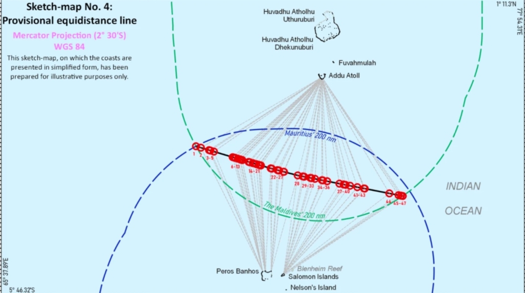
The ITLOS petition does not advocate an equitable or fair demarcation of the 200 nautical miles from Maldives. Instead, Maldives has also agreed to the principle of equidistance or equal division of the disputed territory as requested by Mauritius.
Maldives argued that the boundary should not be measured from the Blenheim Reef as Mauritius wants, but instead measure the sea area from points marked in the two atolls of Peros Banhos and Salomon Islands.
As ITLOS ruled today that Maldives succeeded on that point, meaning that the waters between Maldives and Chagos Islands will divide the disputed territory by measuring the territorial waters of Chagos from the points marked in the two provinces of Peros Banhos and Salomon Islands as requested by Maldives.
With that, more than 45,000 square kilometers of fishing area will be lost from the Maldivian territories.
The chamber that heard the case in ITLOS stated that Mauritius had not presented sufficient evidence to believe that the Blenheim reef was the base-point. The decision also noted that although visible reefs are considered as the coasts of island nations, international law does not provide that submerged reefs can be considered as base-points in sea separation matters.
Special Chamber recognizes that the navigational charts presented by Mauritius depict Blenheim Reef as a single low-tide elevation. However, the Special Chamber cannot accept such charts as conclusive evidence of Blenheim Reef being a single low-tide elevation, as they were produced not to indicate the detailed dimension of Blenheim Reef but to ensure navigational safety around that area.
ITLOS judgement on the “Dispute concerning delimitation of the maritime boundary between Mauritius and Maldives in the Indian Ocean” read.
Maldives experienced lawyers had previously argued that Maldives failure to advocate against the determination of the territory on equitable principles will be detrimental to Maldives as it is likely to lose a large share of the territory to which it is entitled.
In 2010, Maldives filed a complaint with the Commission on the Limits of the Continental Shelf (CLCS) to claim the 200 miles of the natural continental shelf. The commission has not decided on the matter. However, now that the ITLOS case is settled, Maldives will no longer have the 200 nautical miles of territorial waters stipulated under the law.